 Exploring
the Red Rock Pass Area Exploring
the Red Rock Pass Area- When exploring the Yellowstone and
Grand Tetons areas we previously have stayed on the east side of the
Tetons. This year we stayed in western Idaho, camping in Island Park
near Henry's Lake. While on a day trip exploring the nearby Red Rock
Lakes National Wildlife Refuge, we decided to travel north and discovered
this great area. We drive a jeep Wrangler but you don't need a high
clearance vehicle to reach this location. In dry periods the dirt
and gravel roads can be followed to the trailhead parking lot. From
there, you can enjoy a great hike with fantastic views.
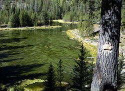
- Although we called the geocache, Otter
Lake (photo on the right), you'll actually see at least four mountain
lakes (Elk Lake, Hidden Lake, Goose Lake, and Otter Lake) on your
adventure. If you drive in from the east, you'll also pass Henry's
Lake.
-
- To get to the hike and geocache, you
can drive in from the east or west.
 From
the west, you'll exit from I-15 at Monida, Montana. It's about 35 miles
to the Red Rock Lakes National Wildlife Refuge. Drive through the Refuge. From
the west, you'll exit from I-15 at Monida, Montana. It's about 35 miles
to the Red Rock Lakes National Wildlife Refuge. Drive through the Refuge.
-
- From the east, you'll be on US 20.
Look for Red Rock Pass Road (also known as Boot Jack Road and FR 053)
heading west. The road will turn from pavement to gravel. You'll pass
the Continental Divide at Red Rocks or Boot Jack Pass, and leave Idaho
to enter Montana. You'll drive about 20 miles from US 20 to reach
the Red Rock Lakes National Wildlife Refuge.
-
- From either direction, look for the
T-intersection for Elk Lake Road and turn north (N 44 36.954 W 111
39.086 elevation 6736ft). The sign says Elk Lake Camp and Hidden Lake
(11 miles). You may want to set your mileage to zero at this turnoff.
At 2.9 miles, you'll leave the Refuge and enter the Beaverhead National
Forest. At 4.4 miles, you'll pass Elk Lake. At 5.3 miles you'll see
the Elk Lake Camp. At 9.2 miles, you'll park and hike the rest of
the way. Park at (N 44 42.828 W 111 36.447 elevation 6800ft). Note
that as you progress northward, the road will get more narrow and
you will have more twisting turns and a few steep hills.
- Hiking the
Trail
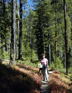
- There are two ways to begin your hike.
You can start at (N 44 42.829 W 111 36.445 elevation 6628ft), first
hiking along the spring outlet to reach the lake and then follow a
path around its shoreline. Or, you can start at (N 44 42.850 W 111
36.459), climb the ridge and then walk through the woods to an overlook
of the lake.
-
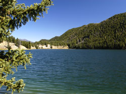
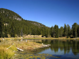
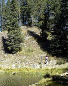
- Both hikes intersect and continue along
the north shore of Hidden Lake (photo above left). You'll reach the
end of the lake in about 1 mile. Then, continue down the valley on
the main trail, walking past several campsites, climb and descend
a few rises, to shortly reach Goose Lake (a small, shallow lake, photo
right) at about 1.5 miles and then continue on to Otter Lake at about
1.7 miles. The geocache is a total of 1.78 miles NE (GPS reading)
from the parking lot.
-
- The geocache is located at (N 44 43.951
W 111 34.957 elevation 6628ft). The total hike is under 4 miles with
side trips and provides a variety of views. Be sure to keep your eye
out for wildlife. We saw signs of deer, elk, and bear, but only saw
ducks, squirrels, and a muskrat. The lakes all have rainbow trout;
you can see large ones in the shallows of Otter Lake and Goose Lake.
Rowboats are available for rental from Elk Camp Resort on both Elk
and Hidden Lakes.
- Placing the Geocache
We placed the cache close to the best viewpoint of the lake just off
the trail. There are mountains in all directions. It was quiet except
for the sound of the rustling pine trees. The day was perfect for
geocaching, it was cool and clear.
-
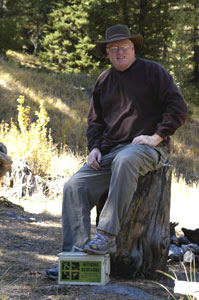
- The tan ammo box cache contains a log
book, a camera, and treasures.
Don't read the italics below if you don't
want to learn the cache location hints.
When you see the sign for Otter Lake,
continue along the trail. Then, hike up the hill. The cache is under
a fallen tree covered with branches. In the photo on the right, Annette
is pointing up the hill at the cache. In the photo at the bottom of
the page, Annette is sitting on the cache.
- Exploring the Geocache
- We have a few suggestions if you want
to visit the geocache.
-
- 1) Be sure to stop and enjoy the National
Wildlife Refuge before or after exploring the cache. Take your time
along the drive and hike. There are very few cars, but there's a good
chance you might encounter animals in the road. Watch for cows on
the road!
-
- 2) There are tons of great places to
camp and hike in the national forest. Bring your tent and spend the
night. If you're RVing and want electricity, try Red Rock RV Park
near Henry's Lake.
-
- 3) The hike would be best in the Fall
or Spring. There's lots of snow in the winter.
-
- We hope you enjoy our geocache! :-)
-
-
Go to the Otter
Lake page at geocaching.com for additional details and logs.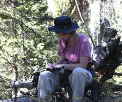
-
-
Created by
Annette Lamb and Larry
Johnson, 09/03. |