- Wolf
Draw Geocache
- Near
Theodore Roosevelt National Park in North
Dakota
|

|
- Exploring
North Dakota
On a trip from
Montana to Missouri, we decided to spend some
time in North Dakota. We were disappointed, but
not surprised to learn that few geocaches have
been placed in western North Dakota. After a
stop at Fort Union Trading Post National
Historic Site in the northwest corner of the
state near Williston, we headed south to the
north unit of the Theodore Roosevelt National
Park. This park is divided into three sections:
a north unit, a south unit, and the Elkhorn
Ranch Site in between. Each area is surrounded
by a combination of private property and public
lands including state and national forests,
grasslands, and BLM areas.
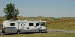
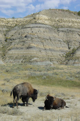
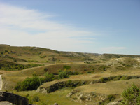
As we drove down
the 14 mile scenic drive at the north unit, we
enjoyed views of the " North Dakota badlands" as
well as a beautiful river bottom. Along with
prairie dog towns, we came across many buffalo
(left) roaming the park. The picture (above
left) shows the RV at the end of the road at the
Oxbow Overlook. In one direction is the rolling
prairie and the other direction is the river and
badlands (above right).
As we drove
toward the south unit, we discussed the beauty
of this unique area of north America and decided
that a geocache might draw more people to
visit.
|
|
Building
our Geocache
On September 11,
2001, we camped in the small town of Medora. It
was a tragic day for the nation, but the
patriotic spirit was strong in the small town
with flags waving. We explored the south unit of
the park on September 12th. At the visitor
center we learned about a gravel road that takes
people to the Elkhorn Ranch site. We decided
that the public land between the National Park
units might be a good location for a geocache.
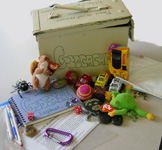
On the right is
a picture of the geocache we created. We placed
the logbook, pens/pencils, geocache directions,
treasures, disposable camera, and garbage bags
(to encourage people to clean up on their way
out) in an ammo case and painted the outside
with the words "geocache" (right).
With our topo
map of the Little Missouri National Grassland in
hand, we headed north through the south unit of
the park. The ranger at the visitor's center
told us that people should always check with
them about the condition of the road before
heading to the Elkhorn Ranch area. It was a
beautiful summer day, so we headed north through
the south unit to the turnoff to the Elkhorn
Ranch Site gravel road. We saw some wild horses
grazing along with road. We soon reached the
park boundary. This area has a mixture of
private and public land. We passed two
well-traveled country roads heading east, but
continued to head north.
At 7.25 miles
from the park boundary, we noticed a rough, dirt
road heading east and decided to do some
exploring. We're sure this road can get muddy
and impassable, so we suggest a 4 wheel drive or
short hike from there. On the map, it shows that
this land is National Grassland, so we thought
it would be okay to place a cache. We drove .25
miles down the road and walked .05 to the top of
the knob from there.
|

|
|
Placing
the Geocache
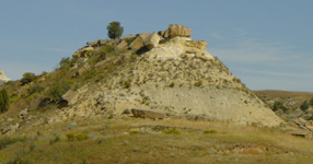
This beautiful
area is filled with small hills and buttes. We
thought the one at the left would be great for a
geocache (notice the juniper tree at the top).
On the crest, we found the lone juniper tree
that would provide nice shelter for the cache
(above right).
We got out our
GPS device and checked the location. The cache
is at - N 47 05 428 W 103 31 939. Being our
first cache, we were nervous about whether we
got the right coordinates, so we went down the
hill , restarted the GPS, and tried our
coordinates. It worked! Cool!
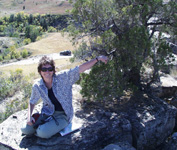
The views of the
area are shown below. The first picture shows
the view to the south, the right shows the view
to the north, and the center picture shows
Annette at the cache.
|

|
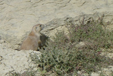
Exploring
the Geocache
We have a few
suggestions if you want to visit the geocache.
This area is home to rattlesnakes and black
widow spiders. Be careful! Also, take care when
you walk on the fragile terrain and don't drive
off the dirt road. You'll find all kinds of
wildlife on the road to the site, so keep you
eyes open. We saw wild horses, a coyote, prairie
dogs, and buffalo. Be sure to explore the
interesting plant life and geology too.
We hope you
enjoy our first geocache! :-)
Go to the
Wolf
Draw
page at geocaching.com for additional details
and logs.
|
-
-
-
Created by Annette
Lamb
and
Larry Johnson,
09/01.
|