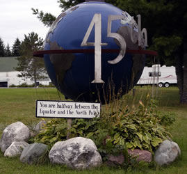
Update: Downeast Day 2 Day two of our Downeast loop trip found us waking early. We picnicked on boiled eggs and V8 juice before heading down/up the road toward the 45th parallel. The Halfway between the Equator and the North Pole geocache location was easy to find. We photographed the answer to the geocache question. We thought it was interesting that the rock stone marker isn't exactly on the 45th parallel. Based on the GPS reading, the marker should be is closer to the outhouse!
|
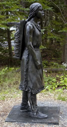
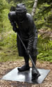
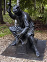
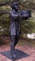
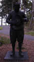
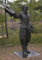
We stopped by a great roadside International Historic Site at Red Beach, Maine. Established in 1984, Saint Croix Island is a joint US-Canadian International Historic Site. 2004 is the two hundredth anniversary of the landing of the French on the island. The new trail opened in October 2003. As you walk along a gravel interpretive trail through the woods, six interpretive porcelain enamel panels along with six larger-than-life bronze sculptures tell the story of Saint Croix Island, the Passamaquoddy people, and the first European settlers. At the end of the path is a view of the 6.5-acre island. |
|
|
In April 1604, Pierre Dugua, sieur de Mons, arrived at the island from France to establish a French settlement. Their choice of an island was for defense, but without fresh water and with limited supplies they eventually abandoned the location and established Port Royal, Nova Scotia. The famous explorer Samuel Champlain created maps and chronicled the expedition. The Passamaquoddy, Micmac, and Mailseet are credited with providing aid to the settlers. From an educator perspective, we thought the interpretive panels were very well designed. They each included interesting reflective questions such as "At the end of August, the ships returned to France. How do you think the settlers felt, knowing that if the ship sunk, nobody would know where you were?" Go to the Saint Croix Island International Historic Site for more information. |
We stopped at a small park to photograph Whitlock's Mill Lighthouse. It looked like a trail would lead to the lighthouse, but the woods contained many downed trees and incomplete path. Eventually, we gave up and decided to just find the Whitlock's Mill Lighthouse geocache and move on down the road. |
Between Robbinston and Calais we looked for the "Pike Milestones." James Pike placed these mile markers between 1860 and 1870. He wanted to clock his buggy's speed. |
Calais - St. Stephens We had expected a couple cute little towns with shops and restaurants, but we were a little disappointed in the Calais, Maine and St. Stephens, New Brunswick areas. They were nice, small towns but lacked the historical, cultural, or artistic stuff we'd expected. The new heritage museum in Calais wasn't even open. The US/Canada border crossing at St. Stephens was backed up, so it took a while to get across. We enjoyed watching people enter into the US. We saw a 5th wheel that was being searched. An officer came out with what looked like a frozen meat package, which isn't allowed. |
We enjoyed finding another geocache. This cache was at the Elm Street Nature Park and hidden on the nature trail. It was a nice walk through the woods and across a wooden footbridge. Next, we headed south on Highway 1 toward St. Andrews-by-the-Sea. |
Saint Croix Island, The Canadian Site The Canadian site has a much better view of the island than the American site. It contains a path with interpretive signs telling the story of Pierre Dugua's first attempt at settlement in North America and his creation of permanent colonies of Acadie and New France. To learn more, go to Saint Croix Island International Historic Site from Parks Canada. To learn more, New Brunswick has a great virtual museum that contains Our Stories, Our People. |
As we entered St. Andrews, we stopped at the St. Andrew's Blockhouse Historic Site. This blockhouse was built during the War of 1812. |
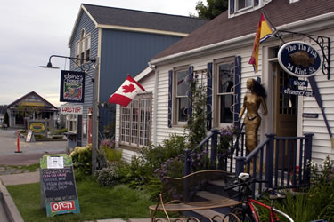
St. Andrews We really enjoyed the downtown area of St. Andrews. This was the quaint little town we'd been seeking. It contained great restaurants, shops, and places to explore.
Pizza Bob made us a great Hawaiian pizza at the Olde Tyme Pizza place. We sat in the window and watched people walk by on the sidewalk. Tour buses frequently stop here, so there were lots of fellow tourists in town. |
 |
Drive Home At 3:30PM we decided it was time to head back to Bar Harbor. The border crossing was easy. After filling with gas, we decided to head back to the Schoodic Unit of Acadia National Park for sunset. While driving backroads, we became fascinated by the many blueberry farms. We found one area particularly interesting. Wyman's farm had a large migrant worker camp area with cabins and other facilities. We wondered about the lives of these seasonal workers. We found some interesting information about these workers on the web.
|
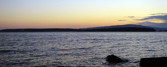
Schoodic at Sunset We arrived at Schoodic right at sunset. Unfortunately there were clouds on the horizon, so the sunset wasn't spectacular. However it was beautiful. We ate the rest of our tuna salad for supper and enjoyed the changing sunset colors before heading back to the RV park.
|
Next Time We'd like to spend more time in the St. Andrews area. It's only an hour and a half to the airports, so it's realistic to spend some time here.
|
Go to Lamb & Johnson Menu
|
 Saint Croix Island, The US Site
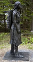
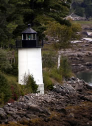 Whitlock's Mill Lighthouse
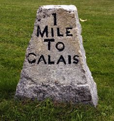 Robbinston
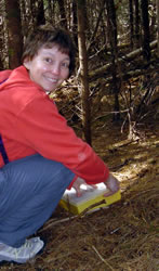 Nature Trail
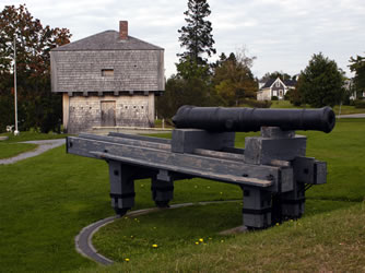 The Blockhouse
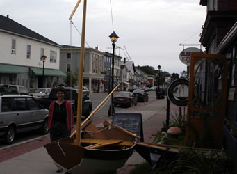
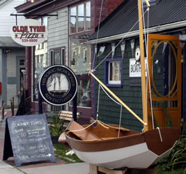 One of our favorite shops was called