- The Big
Island:
- Coastline
& Historical
Exploration
-
- Our third day on the island was spent
driving around the coastline, looking at
the sites, and letting our sore muscles
recover from hiking. We left the volcanoes
park to head to the southern end of
Hawaii. In doing so, we left the newer
lava flows behind and neared the
coastline. Here we began to drive through
farm and ranchland. As we circled the end
of the island and turned west, the land
changed to more dry and arid country.
Average rainfall in Hilo, on the
rainforest side, is 140 inches each year
-- while the Kona (western) side has one
area where only 10 inches fall (that's
desert). This is the Big Island made up of
five volcanoes; two over 13,000 feet tall
- - none of which are truly dead. The
drive around the island is 222 miles.
-
- On the southern end, our first stop
was at the bakery in Na'alehu to purchase
a loaf of their famous Hawaiian
bread. They supply markets all over
the islands, and inspired the sweet round
loaves of Hawaiian bread sold on the
mainland; however, the real thing is a
unique treat. The bakery also serves
sandwiches, great-smelling chili,
pastries, and ice cream. After making our
purchases, we drove onward through more
ranchland. We made another stop at one of
the many macadamia
nut groves that surround the road.
There we inspected the trees and their
bounty. If you've ever eaten macadamia
nuts in cookies or ice cream, they
probably came from The Big Island. We also
saw breadfruit and papaya
trees.
|
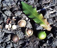 - Macadamia Nuts and
Leaf
|
 -
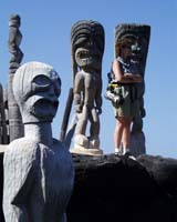 - Wooden
Sculptures
-
 - Ancient
Game
|
- One of our goals for the day was to
visit the three national historic sites on
the island. The first site was the
Pu'uhonua
o Honaunau National Historical Park,
once called the 'place of refuge.' In
ancient times if people violated any of
the many strict rules of the 'kapu' system
such as eating food with a person of the
oposite sex, the sentence was usually
death. Pu'uhonua was a place of refuge. If
the lawbreaker could evade their club or
spear-bearing pursuers to reach this
location, they could be cleansed by
performing rituals dictated by the kahuna
pule (priest). Sounds kinda like the 'safe
or home' location in a game of tag;
however, getting caught off-base here
meant curtains. Anyway this park has some
recreated buildings and displays of
handcrafted outrigger canoes and woven
items. The grounds also contain the Great
Wall, built in the 1500s - - a massive
1,000 ft. wall, 10 ft. high, 17 ft. thick,
and made of cut stones held without
mortar.
-
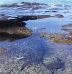
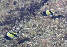
- We spent a lot of our time looking at
the tide-pools in the bay area. We spotted
brightly colored angel fish and more than
a dozen green
sea turtles that were feeding. Like
the giant Leatherbacks that son Ben was
looking after on the western coast of
Costa Rica, these turtles are on the
endangered list. What a treat to see them
in their natural setting. We spent a lot
of time scrambling around the lava and
sand onshore to shoot pictures of the
'honu' (Hawaiian for turtle). They are
especially revered by native Hawaiians and
families bring their children (keikis in
Hawaiian) here to see them.
-
- We left Pu'uhanau to head on through
the west coast town of Kona; this is the
tourist side for golf, beach, and the sun.
The land became more arid as we neared the
NW portion. We spotted a small group of
wild goats on the lava beside the road.
These are feral, descendants of domestic
goats which escaped or were loosed on the
islands. There are very few native
mammals: a bat species and monk-seals.
However many introduced plants and animals
have been there for hundreds of years,
such as Hawaiian geese, pigs, mongoose,
rabbits, bantam chickens, and cats. All
roam free and are considered wild to some
extent. On our travels we didn't see
rabbits or pigs and the only mongoose we
spied was roadkill.
-
- We were disappointed to find that the
second historic site on our list,
Kaloko-Honokohau
National Historical Park, was closed.
The gated entrance was locked and 'danger'
signs could be found on the other side of
the gate. We learned later that the feds
are having a debate with the state over an
access road off the new highway, so the
only way in is to hike a ways from the
adjacent boat harbor. You can still get
the 'cancellation stamp' at the park
service office located in a nearby 'strip
mall', but it's not the same as
visiting.
-
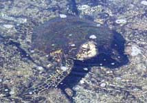
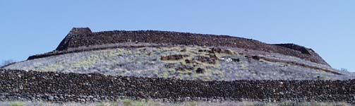
- Next stop of the day was at Pu'ukohola
Heiau National Historic Site. This is
the site of two temples (shown below), the
latest built by King Kamehameha and his
followers in 1790-1791. Thousands of
'volunteer' workers formed a human chain
at least twenty miles long to transport
rocks to the temple site. Less is known
about an older temple, the remains are
downhill and believed to be the ruins of
an agricultural or war temple of
Kamehameha's ancestors.
|
 -
-
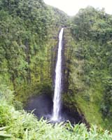 - Akaka
Falls
|
After leaving the historical park, we
headed cross country through the northern
table ranchlands of the island. Our last stop
was a set of falls on the coast just north of
Hilo. Akaka Falls is a 420 foot falls. We
were surprised to see how many people stopped
to view the smaller Kuhuna falls and then
returned to their cars, missing the 'main
attraction' down the trail.
Along the road to the falls area, we found
a beautiful papaya orchard. It was
interesting to see how papaya are grown and
examine the plant closeup. On the way back to
the highway, we stopped for ice cream and a
swing through a wood shop in the small town
of Akaka.
Our drive ended back in Volcano. We even
managed to get to the Volcano
Winery before it closed. We selected some
interesting and unique honey wine.
We enjoyed eating at a neighborhood Thai
restaurant the first night, so we headed back
for more great Thai food at the place called
Thai Thai.
The following day after another great
Hawaiian breakfast, we drove to the airport
for our flight to Maui.
More Information?
|
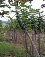 - Papaya
Grove
|
Created by Annette
Lamb and
Larry
Johnson,
12/00-
 - Return
to Trip Page
|